Tag Archives: Great Western Divide

Snowmelt


We’ve enjoyed an unusually cool May with over 2 inches of rain on Dry Creek, enough to bring summer weeds and some green annual grasses back to our grazing ground. Between rains, it’s been overcast, keeping temperatures down, but adding to our humidity—extended weather conditions that have bled into the first week of June to begin our snowmelt in earnest.

On June 6th, temperatures rose to 106° for a short time, then yesterday temperatures rose to 102° as the Kaweah River peaked at 6,662 cfs at 2:00 a.m. to retreat to 2,124 cfs by 11:00 p.m.

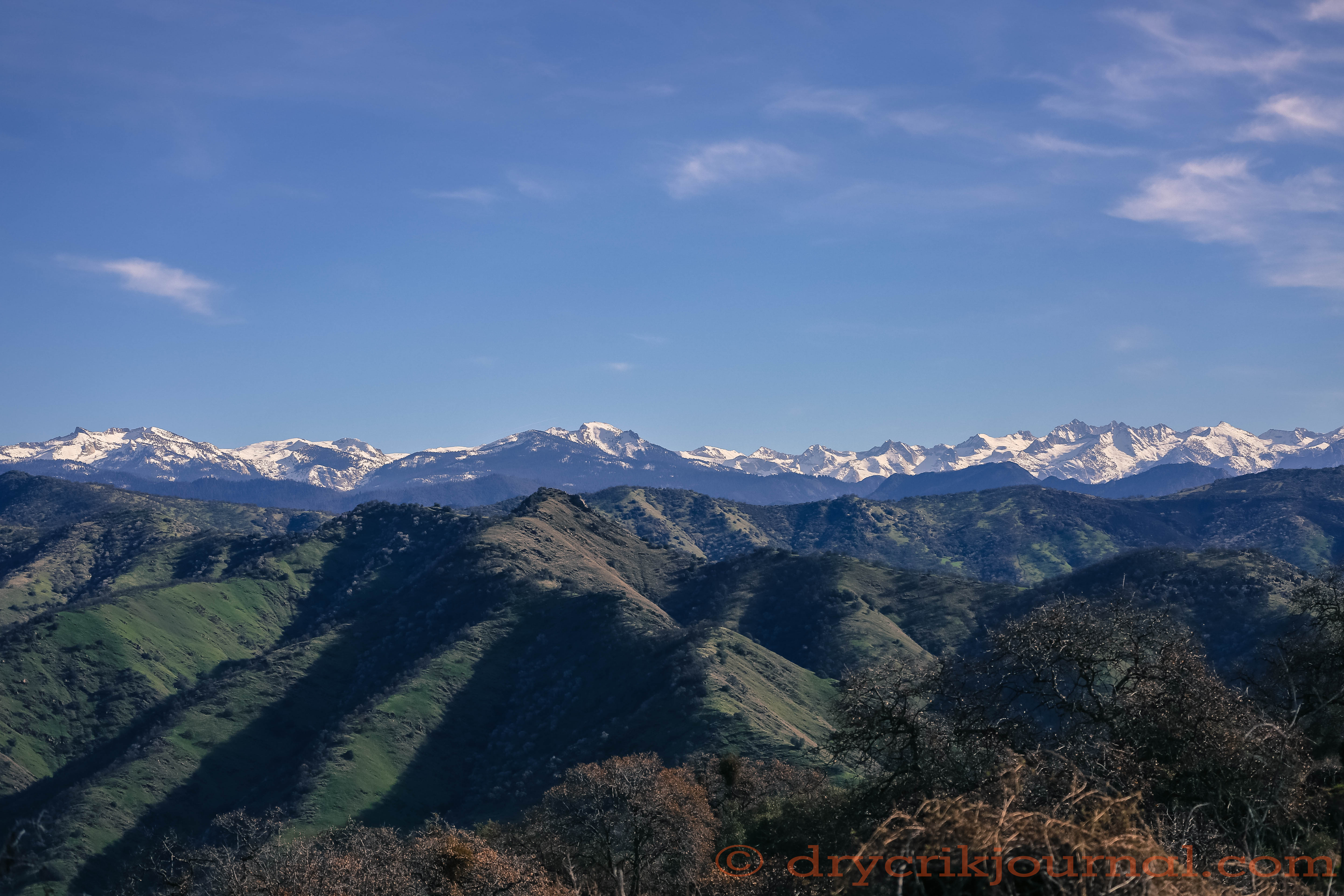
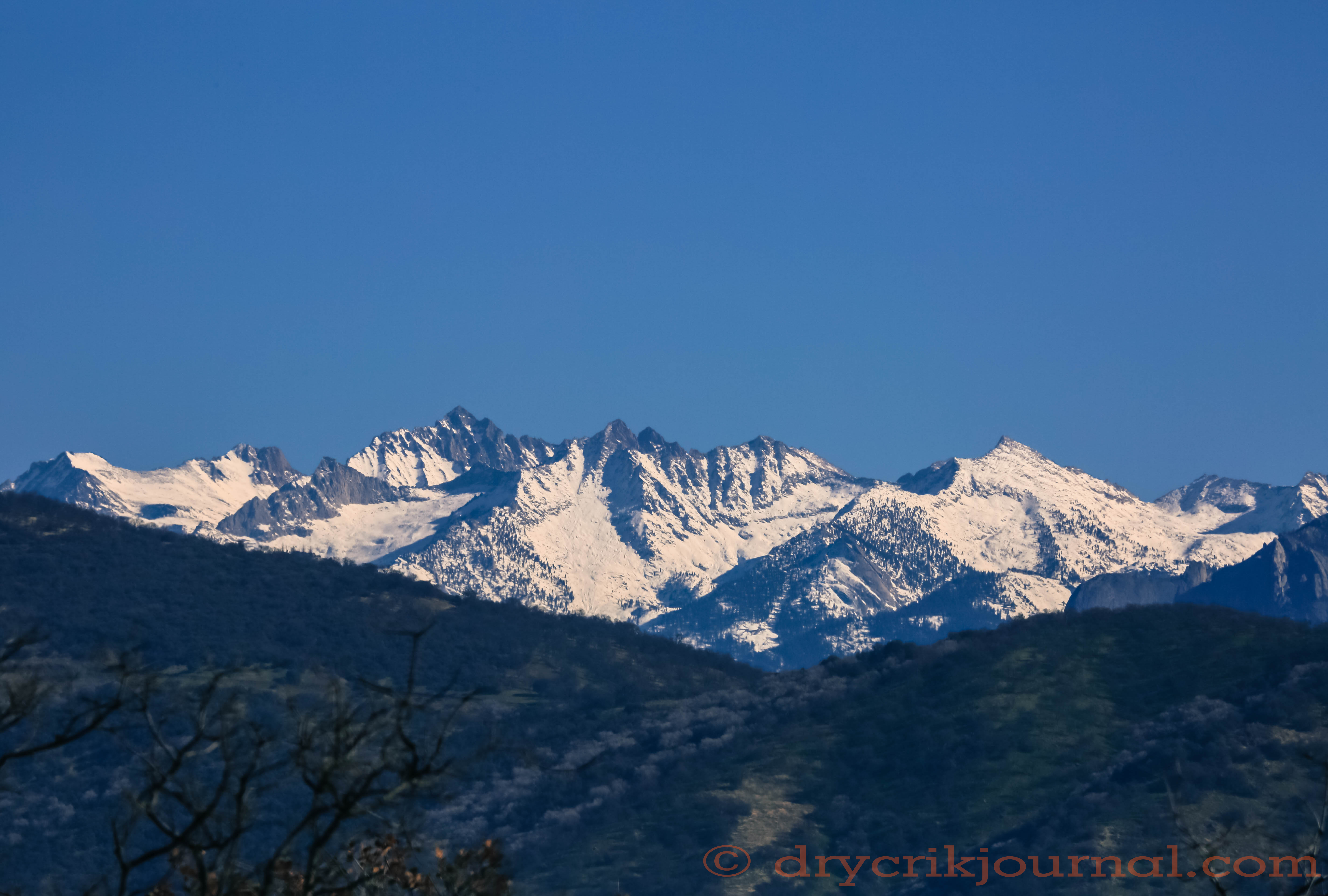
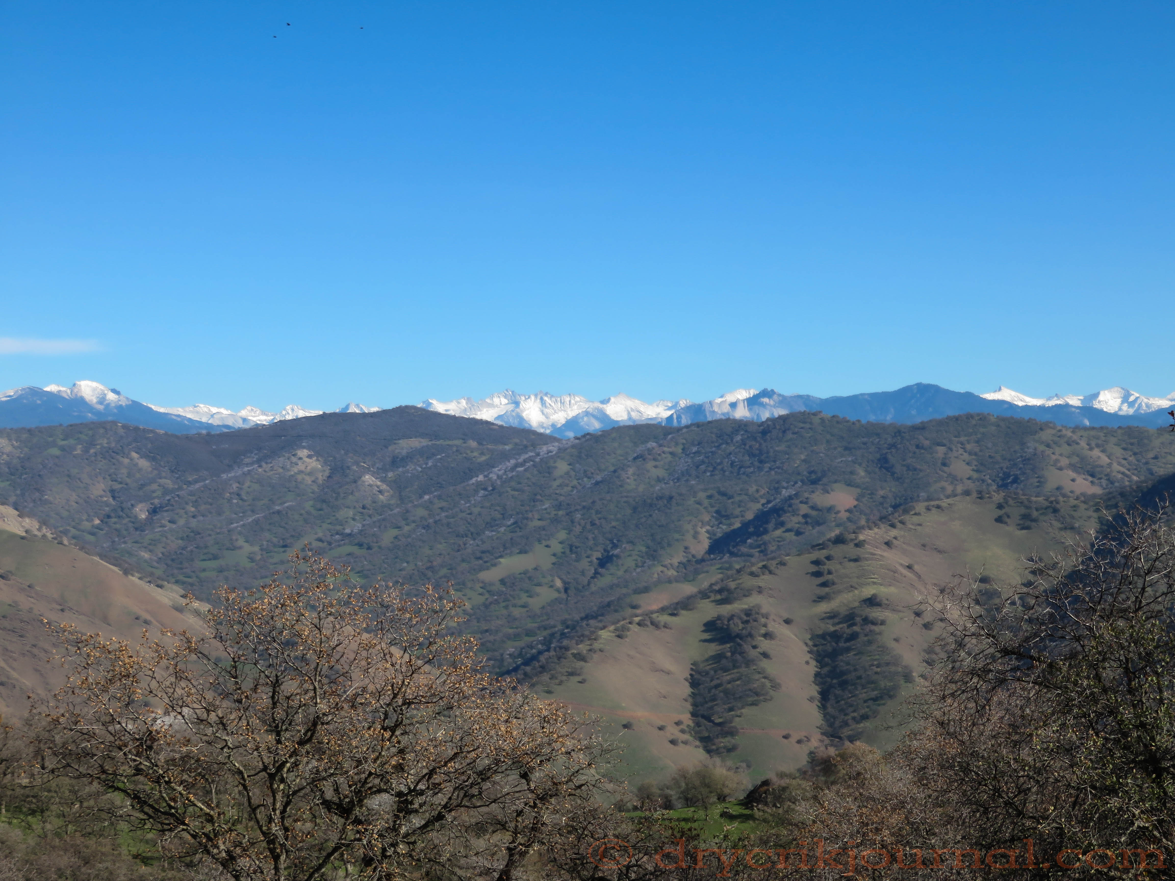
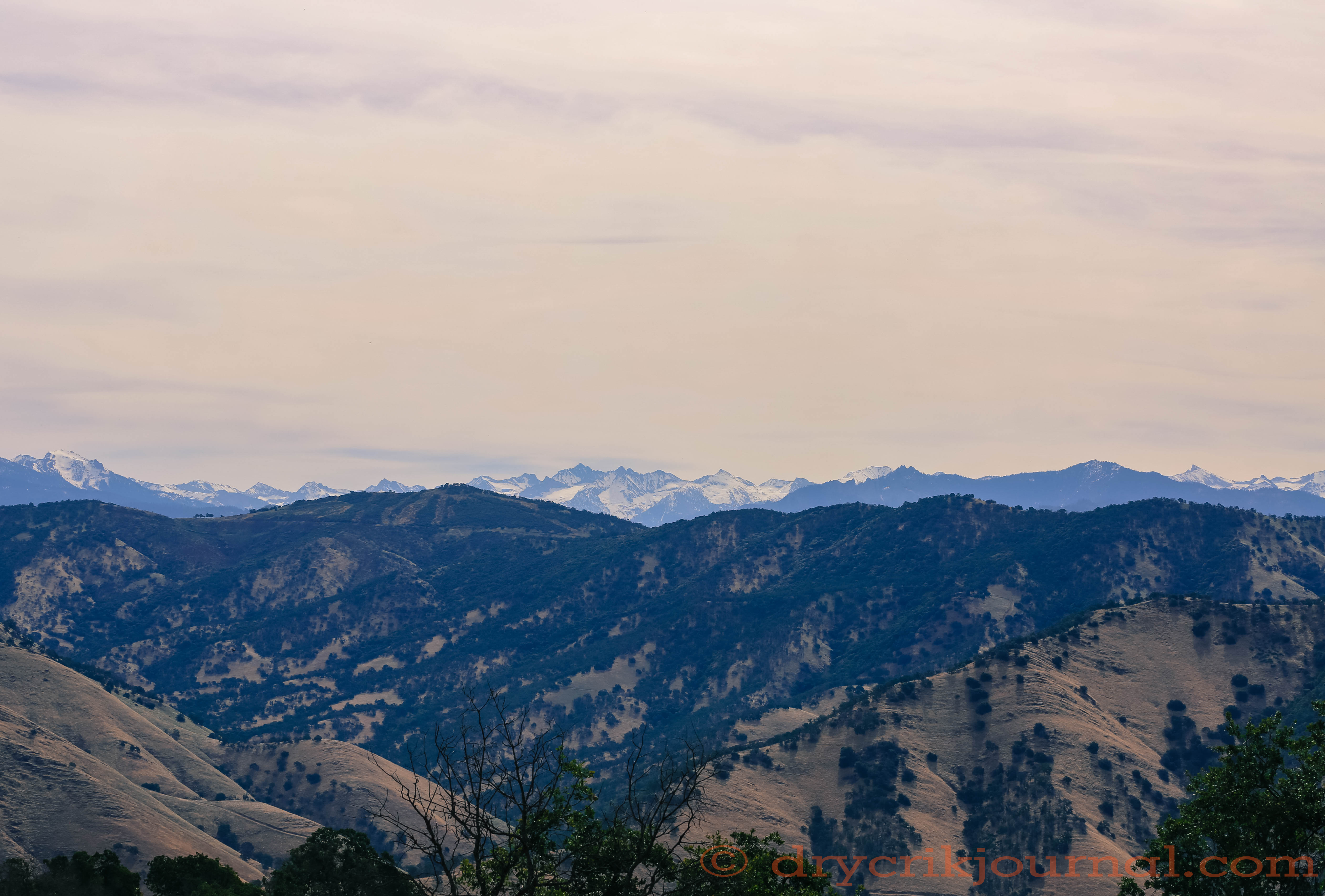
Still overcast this morning when the this photo was taken of the Kaweah River Watershed, from Alta Peak to Sawtooth, there is still quite a bit of snow on the Great Western Divide. Outflow at Terminus Dam has been held steady at 2,596 cfs as the high water at Lake Kaweah creeps up, gaining about 2,000 acre feet in the past 24 hours.

The capacity of Lake Kaweah is 185,000 acre feet. Water behind the dam as calculated by U.S. Army Corps of Engineers is 155,535 acre feet, with room enough for almost another 30,000 acre feet.

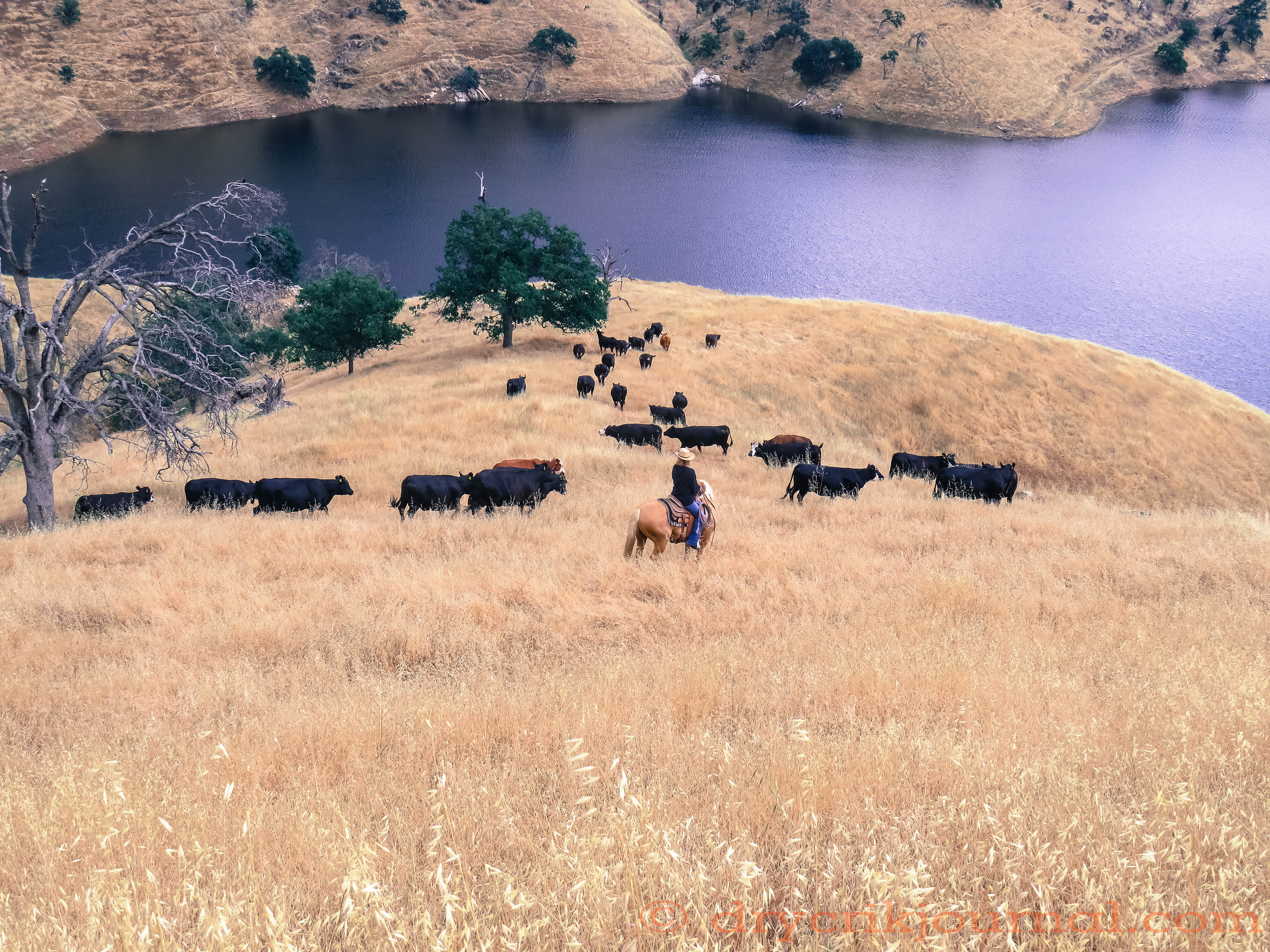
Estimating the water content of the snow remaining and the increasing rate of snowmelt becomes a numbers game for the USACE. Lake Kaweah is beautiful lake and my guess is that it will be full by the 4th of July holidays for water skiers, houseboats and other recreationists. Unfortunately, we worry about fire as the high water mark reaches the dry native feed.

PLEASE BE CAREFUL!!


BLOND ON BLOND


Taking the cows home
a week after weaning
snakes easily over the saddle
and down to the water
of collected dreams.

I remember yellow
Euclid trucks dumping
layers of native pasture
armored with rock
across the river in ’59,

flooding shoreline picnics
and ground squirrels targets
where the Wukchumne camped—
where Loren Fredricks
never learned to swim

afraid of the three-foot carp,
sun-dried, he had to ride upon
in a horse-drawn cart
up Dry Creek to Eshom
before he became a cowboy.

Snow stacked high
on the Kaweahs, we held
the water back when Visalia
was a town, spread the city out
with no water in the ground.

               Blond cowgirl
               on a palomino
               in the wild oats
               above black cows
               and Lake Kaweah—

taking them home
a week after weaning
snakes easily over the saddle
and down to the water
of our collected dreams.


APEX AND RANGE


The ridges are crowded with generations
of relatives and old friends
who came with this ground—

               a native ascension
               a pardon from heaven

for those whose roots won’t let loose
of the baked clay and granite
the weather has chiseled

into crumbling headstones. Easier
to hear their voices, feel them near
as I grow older, closer to them.


The Sierra’s Spine


Snow accumulation is just short of ‘normal’ for this time of year as we head into four days of forecast rain. Going up the hill to help the neighbors get one more bunch branded while we can still get to Mankins Flat, just on the other side of the near ridge.


California Weather Blog: “Wet and stormy week ahead for all of California”


Winter Solstice 2016


20161220-a40a2801


It’s habitual, looking to the mountains for our future, the Kaweah Peaks over Remy Gap in the southern Sierra Nevada above, not completely dressed in snow from the last storm on December 16th— another forecast for the 23rd. Ideally, the snow is laid in while it’s cold enough to freeze before mid-January, then slow melt to feed our rivers and replenish the groundwater in the San Joaquin Valley, once the most productive agricultural region in the world, or so I was told in college.

Much has changed since the 60s when Visalia was a town of 16,000. Now a city populated by 124,000 people drawing on groundwater resources year-round. The growth of Valley towns has also displaced some of our best agricultural ground in a short span of fifty years. The implementation of flood control structures on nearly every river on the west slope of the Sierras since, regulating surface water flows, have also had a severe impact to groundwater levels in the Valley. Add the wild cards of drought and more deep wells, less low snow as the climate changes, ours is not a hand to bet on long.

Well-meaning, but onerous, water legislation will not create more water. Nor will the monies set aside to build more dams, especially since we haven’t filled the ones we have in years. But for us, and most foothill livestock producers, we look to the Sierra snowpack this time of year for our future summer stockwater, the small leaks in granite cracks that feed our springs providing water for cattle and wildlife.


ALMOST MARCH


IMG_5687 - Version 2


Thin veil of snow on the Kaweahs—
granite shows on peaks undressing.
The creek slows and disappears

as the thirsty earth drinks miles
from the river, puddled behind a dam
that will not fill the Valley’s furrows.

Tan medallions, last spring’s leaves
quiver from brittle fingers of oak trees
sprinkling green hills, giving centuries

of rainfall back as decomposing homes
for smaller survivors. It is not over
despite a forecast chance of rain—

dry seasons last, leave evidence only
years of floods can erase. Almost March,
the buzzards have returned early

circling an easy harmony of generations
gone—each clear voice rising,
we hear assurance and good advice.


COWBOY TALK

IMG_2002


We start with trails
that haven’t changed
near the top of the world—

                    switchbacks stacked
                    in scree
                    to gaps between
                    bare peaks like teeth
                    above the timberline
                    chewing at the blue,
                    blue sky

and the solitude

                    waiting in ambush
                    to welcome you home
                    to rainbow trout
                    now spawning,

                    green backs packed
                    in the leak
                    of a snowmelt lake
                    where white clouds
                    float upon water.

                    Alone in the smear
                    of starlight falling
                    upon solid rock,
                    it glows
                    like a lantern.

We start with trails
we know
how to get there.

                                        for Lee and Earl


Two Ranges on the Solstice 2014

IMG_1975


It’s rare to see across the San Joaquin Valley to the California Coast Range anymore, over the small community of Elderwood, from the Paregien Ranch, then look east to the Kaweah Peaks of the Great Western Divide, and Moro Rock in Sequoia National Park — a good air day!


IMG_2006


Sawtooth

IMG_1696

I made a quick tour of Greasy yesterday before the current rain to check our cattle and feed conditions and to cut a Kubota-load of Manzanita. The lighting beneath the cloud cover and view of Sawtooth (elevation 12,343′), above Mineral King Valley in Sequoia National Park, from below Sulphur Peak was eerie and intriguing, enhanced by the 30x telephoto of my point and shoot. Only a light dusting of snow remains from our last storm, but the forecast is for three feet on the Great Western Divide.


Gathering the Paregien Ranch

IMG_1396

Across Dry Creek Canyon, a light dusting of snow on the Kaweahs and the Great Western Divide, from Alta Peak to Sawtooth, as we gathered yesterday to brand today on the Paregien Ranch.

IMG_1381

Almost solid filaree in places, we’ve had a good germination in the granite at the 2,000 foot elevation. Not a lot of grass, but better than in the clay at the lower elevations, our south and west slopes still struggling.

IMG_0576

Clarence and I watch the gate as the girls feed hay where the cows and calves will spend the night. None of our facilities is air tight, so we hope they’ll still be in the pen when we get there this morning.

IMG_1389

Lee, Teri, Robbin and Clarence replay a good gather.

IMG_1402

Forecast rain for Thursday and Friday, we’re hoping to get the calves worked while we can still get up and down the road.