Tag Archives: Kaweah River

Spilling Terminus Dam


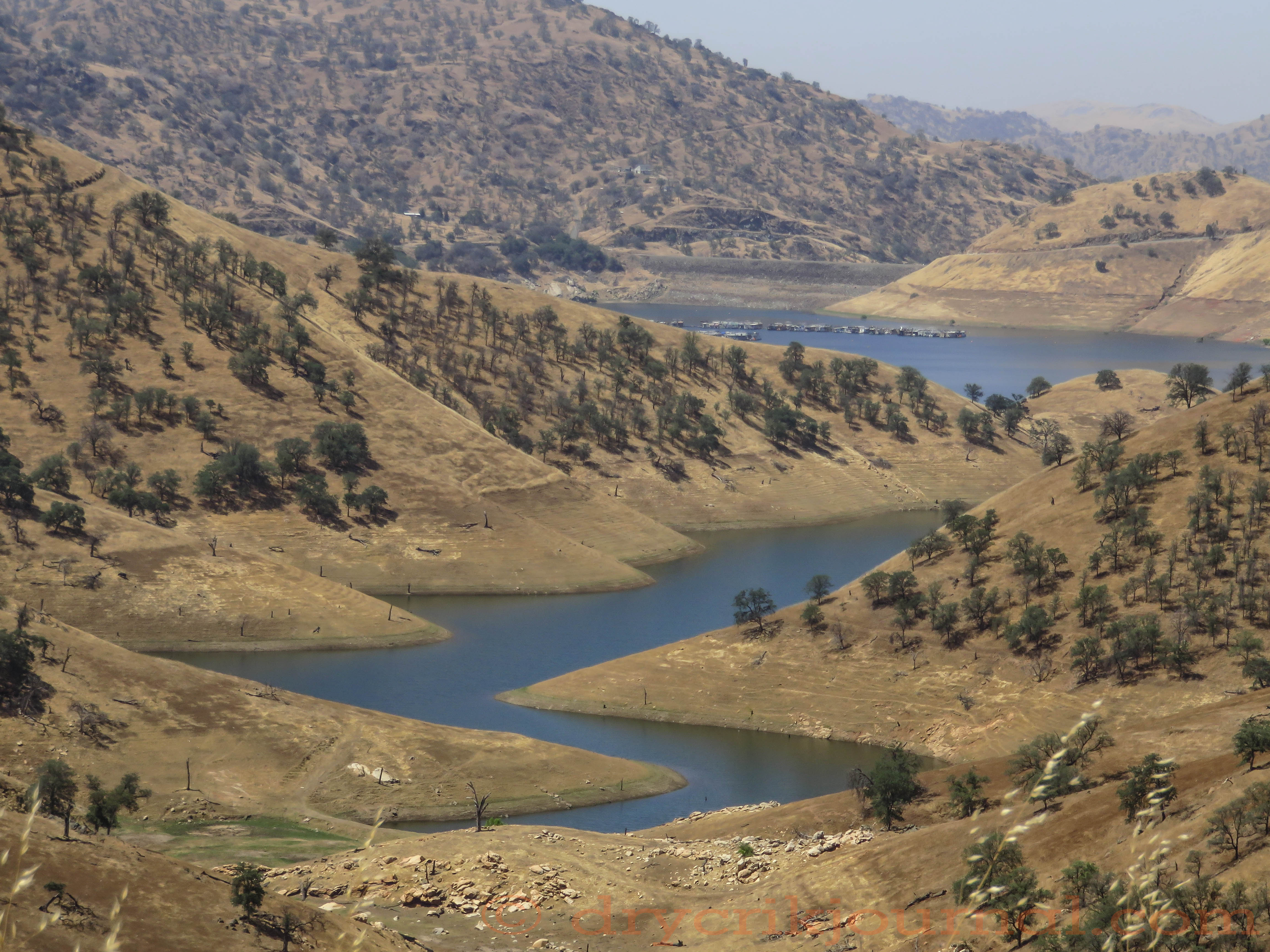
Road closures everywhere, San Joaquin Valley flooded, haven’t left Dry Creek Rd. for a week. Glad we’re on higher ground.  3.5″ more forecast Sunday thru Friday next week.

I am reminded of Christmas Eve, 1955.  Much to my father’s chagrin and contrary to his good judgement, we celebrated with my mother’s parents, Dorothy and Floyd Cutler in Green Acres, Visalia.  Mill Creek ran beside the home and we all took turns watching it rise on the concrete steps leading up from their garage.  When it was time to leave, my Dad carried us three kids and Christmas presents through 3 feet of water to the car, then got the ’53 Buick stuck.  My grandfather hooked on to it with his Studebaker pickup and we drove back to Exeter through the swamps (Lovers Lane to Anderson Road) on the two-lane highway in two plus feet of water (Kaweah River before the Terminus Dam), wincing every time we met another vehicle’s wake in the headlights.  


TERMINUS 1953


               The telephone line goes cold;
               birds tread it wherever it goes.

                    – William Stafford (“The Farm on the Great Plains”)

He was old, but younger than I am today,
digging earthworms for a rusty coffee can,
cane pole and cork bobber for the bass hole

on the Kaweah where he pumped water
for summer pasture before the Flood of ‘55
took it all, but memories, downstream.

In those days, we were rich with time to spend
on foolishness, watching water and bobber
in the warm morning’s sunshine. I call

back occasionally, but there is no ring
on the other end for anyone to answer,
no one left at home, no fish in the bass hole.


Snowmelt


We’ve enjoyed an unusually cool May with over 2 inches of rain on Dry Creek, enough to bring summer weeds and some green annual grasses back to our grazing ground. Between rains, it’s been overcast, keeping temperatures down, but adding to our humidity—extended weather conditions that have bled into the first week of June to begin our snowmelt in earnest.

On June 6th, temperatures rose to 106° for a short time, then yesterday temperatures rose to 102° as the Kaweah River peaked at 6,662 cfs at 2:00 a.m. to retreat to 2,124 cfs by 11:00 p.m.

Still overcast this morning when the this photo was taken of the Kaweah River Watershed, from Alta Peak to Sawtooth, there is still quite a bit of snow on the Great Western Divide. Outflow at Terminus Dam has been held steady at 2,596 cfs as the high water at Lake Kaweah creeps up, gaining about 2,000 acre feet in the past 24 hours.

The capacity of Lake Kaweah is 185,000 acre feet. Water behind the dam as calculated by U.S. Army Corps of Engineers is 155,535 acre feet, with room enough for almost another 30,000 acre feet.

Estimating the water content of the snow remaining and the increasing rate of snowmelt becomes a numbers game for the USACE. Lake Kaweah is beautiful lake and my guess is that it will be full by the 4th of July holidays for water skiers, houseboats and other recreationists. Unfortunately, we worry about fire as the high water mark reaches the dry native feed.

PLEASE BE CAREFUL!!


BLOND ON BLOND


Taking the cows home
a week after weaning
snakes easily over the saddle
and down to the water
of collected dreams.

I remember yellow
Euclid trucks dumping
layers of native pasture
armored with rock
across the river in ’59,

flooding shoreline picnics
and ground squirrels targets
where the Wukchumne camped—
where Loren Fredricks
never learned to swim

afraid of the three-foot carp,
sun-dried, he had to ride upon
in a horse-drawn cart
up Dry Creek to Eshom
before he became a cowboy.

Snow stacked high
on the Kaweahs, we held
the water back when Visalia
was a town, spread the city out
with no water in the ground.

               Blond cowgirl
               on a palomino
               in the wild oats
               above black cows
               and Lake Kaweah—

taking them home
a week after weaning
snakes easily over the saddle
and down to the water
of our collected dreams.


AFTER RAIN


Azure ridge after ridge unfold
into a swirl of storm clouds leaving,
as if heaven sent, wrapping hidden

peaks of scree with snow, thirty miles away
from this conflagration of cottonwoods,
willows and sycamores below. I look

up the throat of the Kaweah for a sign—
hoping, praying, as we begin again,
for grass-fat calves through spring.


GIRLS ON GREEN


20160821-a40a1673


Heads down, our future grazes green
on the edge of time, on ground
the river met with Dry Creek—

all the round cobbles mined
to build the county seat gone wild
with willows and cottonwoods,

natives claiming space we named
between the Kaweah and Wutchumna
Hill. Nothing is the same for us

or them as they mature to become cows.
Heads down, it is easy to forget
to look up at where we’ve come from.


Weekly Photo Challenge: ‘Edge’


Water, Water, Water


Greasy Cove, Lake Kaweah June 17, 2015

Greasy Cove, Lake Kaweah
June 17, 2015

Capacity: 185,000 acre feet
Irrigation water stored June 23, 2015: 50,905 acre feet
Kaweah River Flow, June 24, 2015: 546 cfs (cubic feet/second)


Roughly speaking, 25% of normal.


Weather Journal/2010-11

June 27, 2011

Greasy Cove, Lake Kaweah, 6.27.11

Lake Kaweah, behind Terminus Dam, has only 4-5 more feet to go to get to the reservoir’s high-water mark. The river peaked at about 5,600 cfs for an hour on June 16th, but for 24 hours, cumulatively, June 22nd recorded the highest flow amid four 100º days. Currently about 2,200 cfs inflow to Lake Kaweah, 2,100 cfs outflow. Dry Creek has dropped to 14 cfs, but a lot of water yet for this time of year.


RAISONS D’ÊTRE


                                       Now in the quiet I stand
                                       and look at her a long time, glad
                                       to have recovered what is lost
                                       in the exchange of something for money.

                                            – Wendell Berry (“The Sorrel Filly”)

Looming closer, a swirling darkness just beyond
the thought of summer’s water that is not
frozen deep in the Sierras to feed our rivers

and canyon leaks—of brittle fall and cattle
gathered at an empty trough. The creek dries back
and sinks in March, lifted to new canopies

of sycamores dressing. Skeletons of old oaks
stand out between greening survivors, some
wearing only clumps of yellow mistletoe

hanging like reasons, raisons—like raisins
clinging to a leafless vine. Each season
spins the same dry song, yet we find our place,

harmonize and sing along, lifted like precious
moisture to tender leaves, a basic ascension not
available in the big box stores, unrecorded

in the history of our presence. This may be
the new normal for old people—that daze
of amazement we have been working towards.


ALMOST MARCH


IMG_5687 - Version 2


Thin veil of snow on the Kaweahs—
granite shows on peaks undressing.
The creek slows and disappears

as the thirsty earth drinks miles
from the river, puddled behind a dam
that will not fill the Valley’s furrows.

Tan medallions, last spring’s leaves
quiver from brittle fingers of oak trees
sprinkling green hills, giving centuries

of rainfall back as decomposing homes
for smaller survivors. It is not over
despite a forecast chance of rain—

dry seasons last, leave evidence only
years of floods can erase. Almost March,
the buzzards have returned early

circling an easy harmony of generations
gone—each clear voice rising,
we hear assurance and good advice.


ON THE SEMI-ARID EDGE


The big dogs are drilling deeper,
pumping the last of a million years
of underground water, each river

dammed into furrows to farm
the empty Laguna de Tache.
Sixty years ago, when red lights

stopped in every railroad town,
colorful cornucopias spilled
from billboards onto Highway 99

bragging fruit or vegetable capitals
of another world, and huge Big Oranges
squeezed juice every ten miles.

On the semi-arid edge of change,
we beg for rain and dream of floods
to take this Valley back in time.


                    *     *     *


1876 Tulare County Map

Wiki: Laguna de Tache, Tulare Lake